|
Piri Reis was an Admiral of the Turkish Navy. His birth date is unfortunately
not known but one
at least knows when and how he died. After his time as an Admiral, he
was a governor in Egypt.
There he became a known personality. And even after his long years at
sea, he took great care to
be seen as an educated man. His position enabled him easy access to
old libraries like the one
in Constantinople. Piri Reis wrote a book about maps, were the coasts,
oceans, currents,
as well as shelves and cliffs were drawn. It became a very respectable
book in its time, because,
apart from the above entries, he also drew bays, weather conditions
and possible moorage.
But suddenly the prestige of Piri Reis sank with the leaders of the
land. The reason is
unfortunately unknown. Because he fell in disgrace, he was publicly
decapitated in 1554.
With that, Turkey surely lost one of its most important men of those
times.
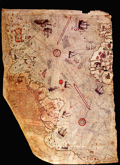
The Piri Reis Map was designed
on the skin of a gazelle, in ca. 1513 in Constantinople.
Even though America was shortly discovered and no geographically exact
diagrams of the new
world were available, the Piri Reis map showed a very exact display
of the American coastline as
well as a few topographic quirks of regions that no European had visited
yet. A few close friends
of Piri Reis stated that he had insight in very old maps, dating back
to Alexander the Great whereby
the most part originated from the ancient Orient. He also mentioned
two Atlantis from where he
also took parts. They contained exact details about the Mediterranean
Sea region and parts
of the Red Sea. Both these Atlantis remained in existence all these
years are are displayed
at the Berlin City Library. These original Atlantis are assumed to be
from the Piri Reis collection.
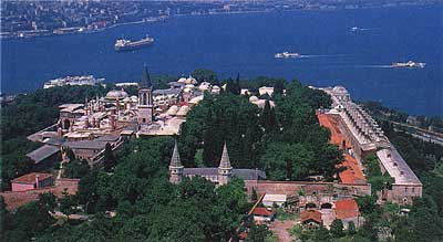
The famous Piri Reis map was lost
for many centuries.
It was discovered by coincidence in the Topkai Palace in Istanbul in
1929.
In 1957 the Piri Reis map was given
to the leading cartographer of the US Navy in order to
be examined in detail. The contracted cartographers made an astonishing
discovery that created
a number of mysteries to this day. The map, centered exactly on the
Giza Plateau in Egypt,
shows not only the exact coastlines and contours of all the continents,
but also their exact
topographical characteristics such as mountain tops, mountain ranges,
islands, plateaus
and even rivers. The exactness of these details baffled the cartographers
of the US Navy.
But not only the known continents and the newly discovered America were
so exactly shown.
Antartica was also exactly mapped! Researchers recently mapped the coastline
of Antartica in
1952 and they managed this only with the newest technology that was
available at the time.
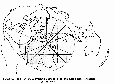
A further peculiarity of the Piri
Reis map is the spherical trigonometry, that is,
the curvature of the earth. Already a few centuries before longtitude
and latitude were used
and before the first globe existed, these lines were already drawn on
the map. More astonishing
is also the exactness of the details even though it was in 1780 when
a standardized longtitude
and latitude system was first used. The deformation that the Piri Reis
map shows is therefore
no error - on the contrary! It is the clear proof that one completed
the map from a height.
Examinations carried out by NASA showed that the deformation resulted
when, for example,
a satellite in orbit is located exactly above the Giza Plateau and takes
a photo of the Earth from there.
NASA took some test pictures using orbiting satellites and their pictures
were then compared
with the Piri Reis map. It was conculded that the map was exactly worked
and there was
only a difference of 1°. This difference can be clarified because
the map was copied by hand
from older sources. It is more astonishing that there was only a difference
of just 1 degree.
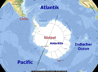
Antartica, drawn in its ice-free
state on the map, was first discovered in 1818
and its coastline was first researched in 1952. How is it then possible
that Antartica is drawn
in such a way on the Piri Reis map? Is there a possibility that a long-forgotten
culture saw
Antartica without ice and researched it? That this culture created the
original maps on which
the Piri Reis map is based? What was this culture, and more, which technical
abilities did it have
in order to create such a detailed map? How is it possible that the
Piri Reis map shows a deformation
that can be proven when one takes a photo from Earth's orbit? There
are endless questions on this
old map and the only one who could answer these questions was Piri Reis´,
as long as he really
knew something about the origins of the original maps. All that we can
do today is wonder
at this map and reach our own conclusions.
|